By Ramachandran Rajeev Kumar — 2026-04-14
The herder and the county seat
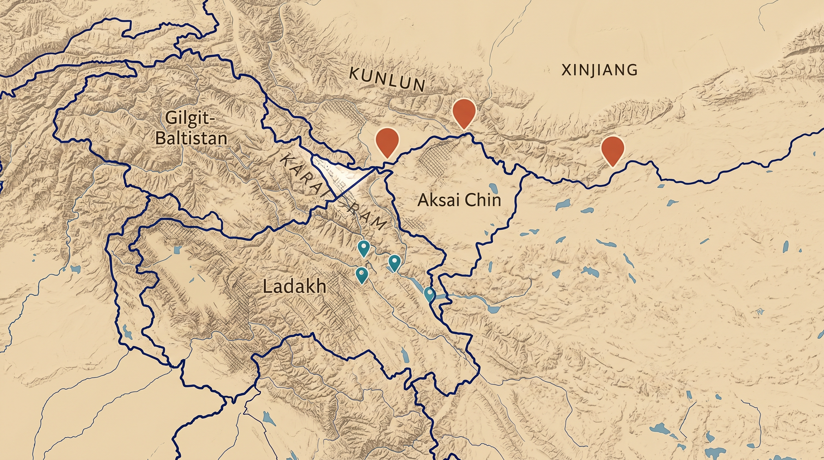
On the road out of Kashgar, before the Karakoram highway bends south toward the Khunjerab Pass, a herder moving sheep across high pasture now does so inside the jurisdictional boundary of a place that did not exist on any Chinese administrative map a month ago. The place is Cenling county. Its county seat is Xinhua Township. It sits in southwestern Xinjiang, under the authority of Kashgar prefecture, within a short drive of the narrow Wakhan Corridor where Afghan territory separates Tajikistan from Pakistan-administered Kashmir and touches China's western border.
Beijing announced the creation of Cenling on March 26, 2026, in a routine bulletin from the Xinjiang Uyghur Autonomous Region government. The language was administrative. The consequence is not. Cenling is the third new county Beijing has carved out on its Xinjiang frontier in a little over 14 months. The first two, He'an and Hekang, were declared on December 27, 2024, under Hotan prefecture, and included significant stretches of territory that India claims as part of Aksai Chin.
Three counties in 14 months is not routine border management. Counties are the most durable administrative unit in the Chinese system. They outlast leaders and five-year plans. They accumulate roads, schools, clinics, party branches and registered populations. A disputed line can be redrawn at a negotiating table. A county that has a budget, a postal code and a decade of census data cannot.
The 14-month pattern
The sequence matters. He'an and Hekang were announced together, with He'an seated at Hongliu Township and Hekang at Xeyidula Township, both carved out of Hotan prefecture in southwestern Xinjiang. Open-source analysis from Radio Free Asia and the Indian press placed parts of both counties inside territory that New Delhi maps as Aksai Chin. The Ministry of External Affairs responded at the time with a standard formulation: India has never accepted the occupation, and creation of new counties does not alter the legal position.
Cenling, 15 months later, completes a pattern rather than begins one. Its location is strategically sharper than He'an or Hekang. It sits near the Karakoram range and within reach of three distinct borders: the Line of Actual Control with India in the western sector, the Karakoram highway corridor into Pakistan-administered Gilgit-Baltistan, and the Wakhan approach from Afghan territory. The county's stated purpose, in Chinese state commentary, is frontier governance and development along transport routes that link China to South and Central Asia.
What Beijing builds with a new county is not a military base. It is something quieter and harder to reverse. Kunyu city, established in Xinjiang last decade under the Xinjiang Production and Construction Corps, offers the template: a township becomes a county or county-level city, the jurisdiction gets road and rail spurs, registered residents follow, schools and hospitals are funded, and a population that was not recorded there a decade earlier now votes in local people's congresses and pays taxes to the centre.
The Xinjiang Uyghur Autonomous Region's internal security apparatus is a separate and much-examined question. This article is not about that. It is about what happens at the prefecture and county level on the western edge of that region, where administrative cartography is being used as strategic cartography. The trijunction of Pakistan-occupied Kashmir, the Wakhan Corridor and the Xinjiang frontier is now administered from Chinese county seats that did not exist 14 months ago.
Why this matters for India specifically
India's claim line in the western sector runs through territory that now sits inside He'an and Hekang. Siachen Glacier, held by the Indian Army since 1984, lies within a few hundred kilometres of the new Xinjiang county boundaries on a straight-line estimate. The Shaksgam Valley, ceded by Pakistan to China in 1963 and never recognised by India as transferable, sits directly in this zone. The distance between a disputed line on a staff map and a county-administered territory with a budget line is the distance between a claim and a fact.
The historical precedent is Tibet. Between 1950 and 1965, the administrative absorption of Tibet preceded its military consolidation. Counties were declared, prefectures organised, a Tibet Autonomous Region created in 1965. The military posture followed the administrative posture. By the time the Sino-Indian war of 1962 made the military question urgent for Delhi, the administrative question had already been settled in Beijing for more than a decade.
The lesson is not that history repeats. It is that administrative facts are the foundation strategic planners build on. A county commits the Chinese central government to budgetary allocations, cadre rotations, infrastructure contracts and security deployments that a disputed zone does not. Once Cenling has a highway, a school, a hospital and five years of tax returns, the question of whether its southern boundary coincides with Pakistan-administered Kashmir or touches Afghan territory stops being a diplomatic abstraction and becomes an operational reality for the People's Armed Police and the PLA Western Theatre Command.
New Delhi's response has historically been cartographic and rhetorical: protest the renaming, reject the claim, reiterate sovereignty. That response is necessary and insufficient. The durable reply to administrative fact-creation is infrastructure. Which brings the question home.
India's 125-project answer
On December 7, 2025, Defence Minister Rajnath Singh stood at the mouth of the Shyok Tunnel on the Darbuk-Shyok-Daulat Beg Oldie road in Ladakh and inaugurated 125 Border Roads Organisation projects in a single day. The total value was approximately Rs 5,000 crore. The mix was 93 bridges, 28 roads and four miscellaneous works, spread across Ladakh, Jammu and Kashmir, Arunachal Pradesh, Sikkim, Himachal Pradesh, Uttarakhand, Rajasthan, West Bengal and Mizoram. The BRO itself described it as the largest single-day project dedication in its history.
The anchor project was the Shyok Tunnel, a 920-metre cut-and-cover tunnel on the DS-DBO road, designed to deliver all-weather connectivity to Daulat Beg Oldie and the forward positions along the Depsang plains. DBO matters because it is the northernmost airstrip operated by the Indian Air Force, a logistics node for the sector that faced the most intense Chinese pressure during the 2020 standoff, and a position where Indian armour can be brought to bear within reasonable response times only if the road behind it is open in winter.
Further east, the Sela Tunnel in Arunachal Pradesh, inaugurated by Prime Minister Narendra Modi on March 9, 2024, at an altitude of 13,000 feet and built at a cost of Rs 825 crore, opened year-round access from Tezpur in Assam to Tawang across the Sela Pass. The Tawang sector is the primary land approach to the eastern Himalayan frontier, and the pre-tunnel situation routinely saw the pass closed by snow for weeks at a time. The strategic argument for the tunnel is that a brigade that cannot be resupplied in February is not a deterrent in February.
The 2026-27 Union Budget raised the BRO's capital allocation to Rs 7,394 crore, up from Rs 7,146.50 crore in the previous fiscal year. The Ministry of Defence's overall allocation rose to Rs 7.85 lakh crore. Lieutenant General Raghu Srinivasan, who took charge as the 28th Director General Border Roads in September 2023 after a career that included postings in Ladakh, Arunachal Pradesh, and Jammu and Kashmir, leads an organisation that has delivered the Sela Tunnel, the Shyok Tunnel and the Atal Tunnel within a five-year window. On the announcement side, the BRO is performing.
A fair accounting would note that the 125-project list is heavier on bridges than on roads, 93 to 28, which reflects where the execution capacity sits and where the easier wins are. Bridges on existing alignments are faster to complete than greenfield roads through difficult terrain. That is not a criticism. It is a description of what the BRO can deliver inside a single fiscal year, and a marker for what remains unfinished.
The geographic spread tells its own story. Nine states and union territories received projects in the December list. Arunachal Pradesh, where the Tawang sector faces the PLA's Lhasa-based formations, is receiving bridge work that reduces response times along the McMahon Line. Sikkim's projects cover the Doklam-facing stretches where the 2017 standoff played out. Himachal Pradesh and Uttarakhand connect forward posts in the middle sector of the LAC. Ladakh alone accounts for the heaviest single concentration — the DS-DBO corridor, the Nimu-Padam-Darcha road, and the feeder network into the Galwan and Pangong sectors. These are the stretches where the 2020 confrontation exposed the cost of thin connectivity.
The execution gap
Announcement is not use. A bridge that is inaugurated but not load-tested for military vehicles is a ribbon, not an asset. A tunnel that is opened but not maintained through a winter is a corridor that may or may not be there when the corridor is needed. This is where a BarathVector article earns its readers, because this is where official communication stops being helpful.
The Comptroller and Auditor General's audit of Indo-China Border Roads remains the clearest published account of the gap. Of 61 ICBRs entrusted to the BRO with a completion target of 2012, only 22 had been completed by March 2016, despite 98 percent of the estimated Rs 4,644 crore having been spent. The audit flagged defective reconnaissance, alignment variances that caused cost overruns, delayed annual works plans, and roads that could not accept the specialised vehicles they were built to carry. A separate CAG audit of Indo-Nepal border roads identified similar patterns of inadequacy and delay.
The 125 projects inaugurated in December 2025 are a newer generation of work, and the BRO under Lt Gen Srinivasan has visibly tightened delivery. But the institutional pattern the CAG described, with survey work skipped, works started before approvals are final, and quality that does not meet specification, does not vanish because the front page is clean. The question India needs to ask is not whether 125 projects were inaugurated. The question is how many of them will be fully load-bearing, maintained, and operationally integrated into Army and Air Force logistics plans by the end of 2026-27. That is a smaller number than 125.
Manpower and equipment also deserve candour. The BRO operates in altitudes and conditions where civilian contractors cannot be relied on for continuous maintenance. The organisation's workforce of general reserve engineer force personnel, casual paid labour and contract-based crews faces chronic gaps at the specialist-operator level: dozer operators, tunnel-boring technicians, heavy crane drivers qualified for altitude work. The capital allocation has risen. The human capacity to convert that capital into operational roads in a single working season has not risen at the same rate.
Connectivity is defence
The closing argument is simple and the discipline is hard. The strategic value of a bridge is not its ribbon-cutting. It is the number of times in a year it carries a convoy of fuel bowsers to a forward post, a battalion of infantry to a new deployment, a medical evacuation out of an altitude-sickness casualty. A bridge unused is an asset lost, because it ties up capital, occupies maintenance attention, and does not deter anything.
China's frontier is being administered from new county seats. India's frontier is being connected from new bridges and tunnels. Both are correct strategic choices for the country making them. The question is whether India's choice will be executed at the pace of its announcement.
Three commitments belong in the next Defence Estimates and the next BRO work plan. First, publish an annual load-bearing certificate for every inaugurated project — not an engineering self-certification, but an operational certificate from the Army or Air Force formation that actually uses the asset, confirming that it carried the specified load in the specified season. Second, fund the maintenance and operator-workforce gap on the same line as the capital build, because a road that is not maintained in its first five winters is a road that will be rebuilt at twice the cost in its tenth year. Third, publish every year a single matched pair of numbers: projects inaugurated that year, and projects from prior years now demonstrably in operational use. The distance between those two numbers is the distance between the country's announcement and the country's answer.
Beijing does not need India to announce less. It needs India to finish more. That is the reply Cenling county deserves.